Combined Simulation Map
In this simple example there are three maps to be combined: Location, Cropping System and Soil.
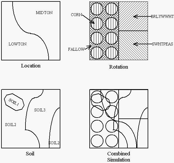
The procedure for overlaying component maps to produce the combined simulation map is detailed in the GIS modual manual
Polygon attribute tables
Most maps (coverages as they are called in Arc/Info) (shape files as they are called in ArcView and ArcGIS) will have an associated table (Polygon Attribute Table in Arc/Info, or simply table in ArcView). The polygon attribute tables will look similar to the following:Note that the association of the filename/code can be made as each of the component polygon attributes tables are created. You may find it more convenient to create code tables associating _ID fields with the filename/code and join these tables to the final combined simulation polygon attribute table as explained in the GIS module manual.
In Arc/Info, the AREA and PERIMETER fields are generated automatically in the polygon attribute table. In ArcView, if you need area and perimeter, you can derive these by adding the fields such as AREA and PERIMETER to your table and calculate the values with the [Shape].ReturnArea and [Shape].AsPolyline.ReturnLength functions.
| AREA | PERIMETER | LOC_ | LOC_ID | LOCATION |
| -5.000 | 12.0 | 1 | 0 | OFFSITE |
| 1.8523 | 7.8 | 2 | 1 | LOWTON |
| 2.1477 | 8.1 | 3 | 2 | MIDTON |
| AREA | PERIMETER | SOIL_ | SOIL_ID | SOIL |
| -5.000 | 12.0 | 1 | 0 | OFFSITE |
| 0.124 | 2.5 | 2 | 1 | SOIL1 |
| 2.01 | 8.5 | 3 | 2 | SOIL2 |
| 1.93 | 6.7 | 4 | 3 | SOIL3 |
| 0.87 | 3.9 | 5 | 2 | SOIL2 |
| AREA | PERIMETER | ROT_ | ROT_ID | ROTATION |
| -5.000 | 12.0 | 1 | 0 | OFFSITE |
| 0.8 | 16.96 | 2 | 1 | FALLOW |
| 1.0 | 4.0 | 3 | 2 | BRLYWWHT |
| 1.0 | 4.0 | 4 | 3 | SWHTPEAS |
| 0.15 | 1.373 | 5 | 4 | CORN |
| 0.15 | 1.373 | 6 | 5 | CORN |
| 0.15 | 1.373 | 7 | 6 | CORN |
| 0.15 | 1.373 | 8 | 7 | CORN |
| 0.15 | 1.373 | 9 | 8 | CORN |
| 0.15 | 1.373 | 10 | 9 | CORN |
| 0.15 | 1.373 | 11 | 10 | CORN |
| 0.15 | 1.373 | 12 | 11 | CORN |
During the overlay operations, the polygon attributes tables from each of the component maps will be joined to produce a polygon attribute table for the combined simulation map that resembles the following:
| AREA | PERIMETER | COMBSIM_ | COMBSIM_ID | ROT_ | ROT_ID | ROTATION | SOIL_ | SOIL_ID | SOIL | LOC_ | LOC_ID | LOCATION |
| -5.000 | 12.0 | 1 | 0 | 0 | 1 | OFFSITE | 0 | 1 | OFFSITE | 0 | 0 | OFFSITE |
| 0.46 | 12.32 | 2 | 1 | 2 | 1 | FALLOW | 3 | 2 | SOIL2 | 2 | 1 | LOWTON |
| 0.06 | 0.534 | 3 | 2 | 5 | 4 | CORN | 3 | 2 | SOIL2 | 2 | 1 | LOWTON |
| 0.11 | 1.232 | 4 | 3 | 5 | 4 | CORN | 2 | 1 | SOIL1 | 2 | 1 | LOWTON |
| 0.02 | 0.023 | 5 | 4 | 5 | 4 | CORN | 2 | 1 | SOIL1 | 3 | 2 | MIDTON |
| 0.01 | 0.043 | 6 | 5 | 5 | 4 | CORN | 3 | 2 | SOIL2 | 3 | 2 | MIDTON |
| 0.17 | 2.946 | 7 | 6 | 2 | 1 | FALLOW | 3 | 2 | SOIL2 | 3 | 2 | MIDTON |
| 0.14 | 1.32 | 8 | 7 | 2 | 1 | FALLOW | 2 | 1 | SOIL1 | 3 | 2 | MIDTON |
| 0.01 | 0.023 | 9 | 8 | 6 | 5 | CORN | 2 | 1 | SOIL1 | 3 | 2 | MIDTON |
| 0.14 | 1.372 | 10 | 9 | 6 | 5 | CORN | 3 | 2 | SOIL2 | 3 | 2 | MIDTON |
| 0.14 | 1.325 | 11 | 10 | 3 | 2 | BRLYWWHT | 3 | 2 | SOIL2 | 3 | 2 | MIDTON |
| 0.73 | 2.953 | 12 | 11 | 3 | 2 | BRLYWWHT | 4 | 3 | SOIL3 | 3 | 2 | MIDTON |
| 0.12 | 1.126 | 13 | 12 | 2 | 1 | FALLOW | 2 | 1 | SOIL1 | 2 | 1 | LOWTON |
| 0.12 | 1.382 | 14 | 13 | 7 | 6 | RLYWWHT | 3 | 2 | SOIL2 | 2 | 1 | LOWTON |
| 0.02 | 0.008 | 15 | 14 | 8 | 7 | WHTPEAS | 2 | 1 | SOIL1 | 3 | 2 | MIDTON |
| 0.13 | 1.532 | 16 | 15 | 8 | 7 | CORN | 3 | 2 | SOIL2 | 3 | 2 | MIDTON |
| 0.37 | 0.065 | 17 | 16 | 8 | 7 | CORN | 4 | 3 | SOIL3 | 3 | 2 | MIDTON |
| 0.21 | 1.433 | 18 | 17 | 2 | 1 | FALLOW | 4 | 3 | SOIL3 | 3 | 2 | MIDTON |
| 0.02 | 0.042 | 19 | 18 | 2 | 1 | FALLOW | 3 | 2 | SOIL2 | 3 | 2 | MIDTON |
| 0.19 | 2.983 | 20 | 19 | 4 | 3 | SWHTPEAS | 4 | 3 | SOIL3 | 3 | 2 | MIDTON |
| 0.01 | 0.009 | 21 | 20 | 8 | 7 | CORN | 3 | 2 | SOIL2 | 3 | 2 | MIDTON |
| 0.15 | 1.373 | 22 | 21 | 9 | 8 | CORN | 3 | 2 | SOIL2 | 2 | 1 | LOWTON |
| 0.10 | 1.369 | 23 | 22 | 10 | 9 | CORN | 3 | 2 | SOIL2 | 2 | 1 | LOWTON |
| 0.05 | 1.034 | 24 | 23 | 10 | 9 | CORN | 4 | 3 | SOIL3 | 2 | 1 | LOWTON |
| 0.06 | 0.824 | 25 | 24 | 2 | 1 | FALLOW | 4 | 3 | SOIL3 | 2 | 1 | LOWTON |
| 0.29 | 2.132 | 26 | 25 | 4 | 3 | SWHTPEAS | 4 | 3 | SOIL3 | 2 | 1 | LOWTON |
| 0.29 | 2.459 | 27 | 26 | 4 | 3 | SWHTPEAS | 5 | 2 | SOIL2 | 3 | 2 | MIDTON |
| 0.15 | 1.373 | 28 | 27 | 11 | 10 | CORN | 3 | 2 | SOIL2 | 2 | 1 | LOWTON |
| 0.15 | 1.434 | 29 | 28 | 12 | 11 | CORN | 3 | 2 | SOIL2 | 2 | 1 | LOWTON |
| 0.21 | 1.921 | 30 | 29 | 4 | 3 | SWHTPEAS | 3 | 2 | SOIL2 | 2 | 1 | LOWTON |
| 0.13 | 1.725 | 31 | 30 | 3 | 2 | BRLYWWHT | 5 | 2 | SOIL2 | 3 | 2 | MIDTON |
| 0.03 | 0.063 | 32 | 31 | 7 | 6 | CORN | 2 | 1 | SOIL1 | 2 | 1 | LOWTON |
The overlay operation effectively generates all possible simulation scenarios that appear in the map.
Preparing parameter files
The parameters files used in the GIS and Watershed project simulations are normal CropSyst parameter files.You will need to have all the parameter files that may be specified in the combined simulation map polygon attribute table. Any parameter file that is missing will cause the Coöperator or Watershed simulator to skip the run and tally of that polygon since the simulation will assume the polygon to be an "offsite" area.
HOW to prepare a combined simulation map?
Combined simulation maps can be prepared using either ArcView, Arc/Info or ArcGIS.Before overlaying maps, make sure that you have added the column to the each polygon attribute table for the soil, and/or rotation and/or location respectively as described above.
Normally the overlay is done using the UNION mode function, in some situations, the INTERSECT function may be more useful.
If you are combining several maps, this process will require more than one UNION or INTERSECT function to create the final combined simulation map.
- Using Arc/Info
- Overlaying maps requires the Overlay module. In some versions this supplemental module is not included in the basic Arc/Info package and must be purchased separately.
In Arc/Info use the OVERLAY command with either UNION or INTERSECT subcommand/option.
Note that if your soil, rotation, etc. maps are combined using the UNION or INTERSECT function the tables will be automatically joined.
- Using ArcView
- Overlaying maps requires the Geoprocessing extension to be enabled. The geoprocessing extension can be enabled in the File/Extensions menu.
Refer to the ArcView help for further direction in using the GeoProcessing functions. Unlike the UNION and INTERSECT function in Arc/Info, the ArcView geoprocessing extension functions do not generate unique ID numbers for polygons in the combined map. The CropSyst GIS module requires a unique ID field for the polygons. This can be created as follows:
- Add a field to your shapefile table, you can this field anything you want (I.e. "UID" for unique ID). This is the polygon ID field you select in the GIS module editor.
- Using the ArcView map calculator, Calculate [UID] = rec + 1 in the field calculator. This gives unique ids to all records.
- If you need area and perimeter, you can derive these by adding a few more fields such as UArea and UPerimeter. Calculate them with [Shape].ReturnArea and [Shape].AsPolyline.ReturnLength.
The process of combining the maps with the union or intersect functions along with assigning the unique ID number will prepare the polygon attribute table
If you look at the ArcView menu Theme/Table you should be able to display the table. You should find the .DBF file that is the table in the same directory as files associated with the coverage.
Sometimes the table from ArcView coverages are stored internally, you can export to the .DBF format as follows:
- Display the table for the view with the menu Theme/Table
- Click on the table window (make it active)
- The export function is available from the menu File/Export
- Select dBase format
- Enter a filename.
- This is the same filename you use for the polygon attribute table .DBF name in the GIS project .
Unfortunately, sometimes the ArcView geoprocessing extension doesn't work right. The free XTools extension from ESRI may do a better job and provide other functions you may find useful.
The free XTools extension is available at www.esri.com/arcscripts, this Web site describes their functionality. XTools will maintain attribute information while doing overlay analysis more effectively than Geoprocessing Wizard. Also at the XTools Web site, there is documentation about some of the bugs in ArcView overlays.

Heading using the h3 tag
Lorem ipsum dolor sit amet, consectetur adipisicing elit, sed do eiusmod tempor incididunt ut labore et dolore magna aliqua. Ut enim ad minim veniam, quis nostrud exercitation ullamco laboris nisi ut aliquip ex ea commodo consequat. Duis aute irure dolor in reprehenderit in voluptate velit esse cillum dolore eu fugiat nulla pariatur. Excepteur sint occaecat cupidatat non proident, sunt in culpa qui officia deserunt mollit anim id est laborum.